A number of states have championed the use of GIS to strengthen the accuracy and reliability of their electoral systems in recent years, and NSGIC’s Geo-Enabled Elections project was created to further this goal across the country.
So how does a state – or any election authority – get started on this important work? The project recently released its first-year report, and with that a draft set of best practices. These will be put to the test and further refined through a number of case studies and through five statewide pilot studies during the project’s second year, with a final report in September 2019.
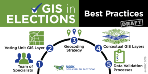
The draft best practices are, in headline form:
- Convene a Team of Specialists
- Collect and Sustain a Statewide Voting Unit GIS Layer
- Adopt and Implement a Statewide Geocoding Strategy
- Assemble and Provide Best Available Contextual GIS Layers
- Define and Implement Data Validation Processes
To view the best practices in full and to learn more about NSGIC’s work to support states in deploying GIS technology to increase accuracy and gain efficiencies in their election data management processes, you may download a complete copy of the first-year report HERE, or click here to learn more about the Geo-Enabled Elections project.

